Wednesday, March 30, 2022

Enos Lake - my type of hike

Last Friday, my hiking partner and I chose a hike that we had not done since September 2020 - Enos Lake in Nanoose Bay.  This would be our third hike there.  Last summer and fall, the trails were closed due to the fire hazard, and then atmospheric rivers of rain made late fall and early winter hikes there ill advised.  It had been far too long since we'd been there. 


As hikes go, it is an enjoyable length for us, with just the right amount of challenge - offering some cardio on the moderate elevation gains and descents, forest trails, ponds, meadows, bluffs, views, and lakeside spots for lunch. There are loops and cross trails and lots of options allowing for longer or shorter distances, but we covered 4 miles and took about three and a half hours including stops for lunch, photography, and just inhaling the beauty around us. 

We began from the parking lot on Fairwinds Dr.  Wandering down a trail (which somehow becomes twice as steep on the return trip!), we crossed a little bridge and turned right at the t-intersection, heading into a route sometimes referred to as The Enchanted Forest Trail.


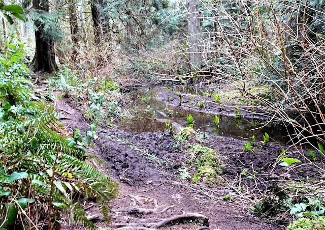
The trail of soft dirt with some roots, crosses Fairy Creek a couple of times, rustic bridges or boards and logs making the crossing easy.  There was only one mucky section this day, in an area swampy enough to sprout Skunk Cabbage, also known as swamp tulips, bear's salad bar, and several other names.  Whatever you call it, it's bright yellow popping up in early spring is always a welcome sight. 


Both times we'd visited before had been in the fall, when the creek was quite dry, so we had never seen the lovely little waterfall alongside the trail.  We caught our first glimpse of it through the trees, and then followed some little side trails to get a closer look.


It tumbled quite a ways down, levelled out, and then tumbled again.  One could almost imagine little woodland fairies sliding down the last section of falls into the clear little pool below, giggling and chattering as they play.


Continuing on, we spotted the first blossoms of the red currant bushes (edited: actually, I think these are probably salmonberry blossoms. Both are in bloom right now, and they look very similar), native to the island. We soon saw the first glimpses of Lake Enos and chose a lower trail that skirted the bottom of a hilly section before climbing up to join the upper trail across the mossy bluffs. 


From the bluffs, we passed a pond, rounded the end of the lake, and headed along a trail down the other side.  Eventually, as we knew we would, we ran out of trail at a lovely little spot where a fallen log offers the perfect lunch spot by the water's edge, a canopy of evergreens overhead, and perfect solitude in which to listen to the many birds, the frogs, the splashing of ducks.  

Our beautiful, very solitary lunch spot on the lake.

The lake is home to an evolutionary phenomena where two species of fish have devolved into one.  An article in the Times Colonist in 2016  tells how the three-spined stickleback (a little fish common to coastal BC) has two distinct populations, with different sizes and habits. One type Benthic) lives closer to the shore, feeding on aquatic plants and insect larva. The other, smaller species (Limnetic) live in deeper water and fed on plankton.  But back in the 1990s, someone introduced the signal crayfish to Enos Lake, who then disturbed the deep water species, eating the eggs and preventing others from hatching.  So what did the deepwater stickleback do? They started interbreeding with the inshore sticklebacks, lived closer to shore, and changed their diet until finally the inshore and deepwater subspecies merged into one single hybrid species, sometimes referred to as the Enos Lake Stickleback. The implications are far reaching as it has since affected both plankton life and insect life in the region. 


We didn't see any little fish, though we did see lots of little insects. And out in the water on a small island covered with sedges and reeds, we could hear birds enjoying the spring weather.  Zooming in, I spotted two little brown singers, wrens I think, picking away at seeds on the sedge. 


To our knowledge, there is no trail that circumnavigates the whole lake, so we headed back the way we came.  Back to the end of the lake, we stopped once more to admire the view:


We then continued back up to the pond, but took the trail to the opposite side where we followed it alongside the pond, stopping frequently to watch the many ducks - mallards and hooded merganser and even some ring-necked ducks. 
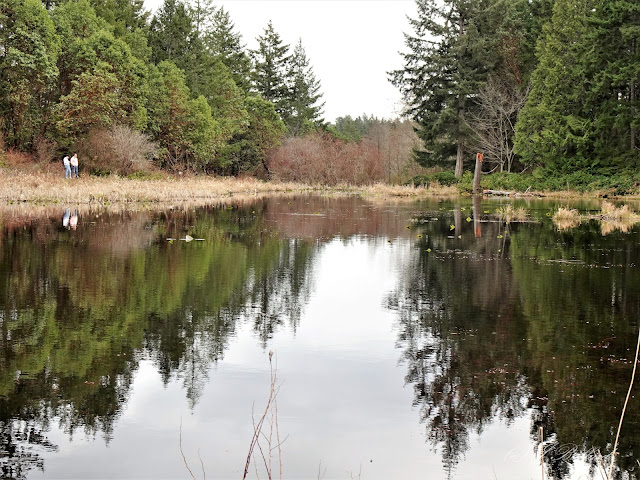
View of the pond - and two of the very few people we saw all day.

Ring-necked ducks (no ring around their necks, but they do have rings around
their very funny looking beaks). Mallard in background. 

Hooded merganser - more often seen in ocean bays.

Hummingbirds were zipping around though none let me get a photo of their brilliant colours - just one silhouette against the sky. 


We took a different trail back, to come out to the left of the first Fairy Creek bridge where we had previously turned right.  Wandering back up the trail to the car, we spotted several little wooden creatures perched in trees. Wooden owls have shown up on trails all over the island, and most were likely from the same carver, but this little guy that I posted the other day was different from the typical owls and ended our delightful day with yet another smile as we headed home. 


Compared to our previous week's hike to Ammonite Falls, with its many stairs and dozens of people, there's no doubt in my mind that this is the better choice.  The falls may be much smaller, but the journey so much better! 

(Note:  Nearly every review and summary of the Enos Lake hike mentions something we also found:  the trails are very confusing and the maps are not very accurate as they omit a  lot of the cross-trails. The trails themselves have no markers, and maps are infrequent.   We also discovered at least one of the maps has the 'you are here' pin at the wrong trail intersection!  Our first hike here was the only time in years of hiking together that we have had to use our compasses to find our way back to the car.  Fortunately, there are several trails that lead out to residential areas so, while you may not end up back where you parked your car, you are unlikely to have to spend the night in the wilderness.) 

Monday, March 28, 2022

Woodland creature

Sunday afternoon,  I was in the middle of preparing a blog about Friday's hike when I was interrupted by a somewhat urgent strata issue (I'm president of the strata council) that took up some time, after which I'd totally forgotten what I was doing and moved on to other chores!  So I'll leave you one photo of a 'woodland creature' we saw on our hike, just so you can start your day with a smile.  The rest of the photos are all ready to go but the words are not - I will try to get back to them within a day or two.  Happy Monday, everyone. 


Monday, March 21, 2022

Ammonite Falls - the hike of a thousand steps

Okay, it wasn't a thousand steps (as in, steps on stairs) but it was over 900 total - yes, my hiking partner counted them!  Throw in some very slippery slopes, and a pretty ordinary waterfall compared to many we've seen, and this won't be a hike these two seniors are likely to repeat.  At least, not from the new Weigles Road parking lot.  


Let me begin at the beginning.  Ammonite Falls was on my bucket list of hikes I wanted to do while living here on beautiful Vancouver Island.  I'd seen it talked about on numerous blogs and Facebook hiking pages.  While the photos were not as pretty as those from some other hikes, the hype from people who "loved it!", thought it "spectacular" and made it sound like a short stroll in the park ("easy peasy!"), had my adrenalin pumping.  


Ammonite Falls is so named because of the many fossils found in the area, as well as in the layers of sedimentary rock around the waterfall itself.  The largest of the ammonite fossils - almost a meter across - was found by two hikers in 2012.  Ammonites were snail-like creatures that were common in the Paleozoic and Mesozoic oceans 400 to 65 million years ago (
sources: Nanaimoinformation.com; Timescolonist.com).  According to www.abitsalty.ca, ammonites may look similar to snails, but are more closely related to the modern octopus, and became extinct around the same time as the dinosaurs. The history alone was enough to make me want to hike there. 

The only thing that made me hesitate to do this hike, until now, had been the mixed ratings on various popular social media sources, official parks pages, and hiking books and apps - from the 'easy peasy' mentioned previously to 'easy-moderate', to 'moderately challenging', to 'moderate-difficult'.  From what I gathered, the majority of the trail was a gentle up and down, and therefore easy (or easy-moderate because of roots on the trail and some mud in the rainy season), and the difficult or challenging part was once you reached the falls.  Sources prior to this year indicated that only the top corner of the falls would be visible unless you were capable of shinnying down a very slippery long and steep slope, assisted by a rope or two, to reach the bottom for the full view.  So, knowing that my hiking partner and I, both in our seventies, would not be doing the rope acrobatics, we opted for other more rewarding trails. Until this year.

During covid, I kept reading reports that the Regional District of Nanaimo was making improvements to the Benson Creek Falls Regional Park, in which Ammonite Falls is located, with a special focus on making the falls more accessible.  A large parking lot at the trailhead, a bridge over Benson Creek to replace the existing log, and a set of steps down to the bottom of the falls, all made the trail sound doable and rewarding for us.  So once we heard the project was completed, off we went. 


What I didn't realize was that the large parking lot was not in the same location as the more commonly used trailhead that 99% of those rating the trail used.  In fact, Nanaimonewsnow.com stated  the improvements included "a new trailhead, kiosk and 40-stall gravel parking lot near the currently undersized lot", and that the new parking lot was "located 100 meters past the existing lot" (emphasis added).  Perhaps there was a trailhead to the park from that area, but it sure wasn't the primary trailhead to the falls and nowhere near the Jameson Rd trailhead used by hiking sources and reviews. It is, in fact, in a network of extensive mountain bike trails, with warnings to hikers at cross trails. 

While meant to relieve the pressure from the Jameson Rd neighbourhood whose street and driveways were blocked by inconsiderate hikers, the new parking lot for forty cars on Weigles Rd took hikers to the falls from the opposite direction, a trail where the middle third is designated 'difficult' - in fact, after hiking for 20 minutes or so, we came to a large sign highlighting just that and warning that it may not be suitable for all hikers.  Perhaps that sign was always there for those who came in from that approach prior to the improvements, but the only previous mention that I had found of the hike to the falls being 'difficult' talked only of the roped slope down to the bottom of the falls. 

So... after a fairly comfortable walk we hit the 'difficult' section.  The section had been improved with not only a bridge over Benson Creek but also two very long sections of stairs - some with handrails, some without.  Handrails were plastic-covered cable, which may be longer lasting than previous rope handrails we've encountered on hikes, but were themselves very slippery with moisture and therefore not very useful. And steps are never designed with short legged people in mind, necessitating what I call my 'toddler climb or descent' - move one foot, bring second foot up (or down) to meet it.  Next step, move one foot, bring second one up to meet it.  And so on.  That gets exhausting in a very short while.  Each set of steps had approximately 150 risers, except for a few shorter sections of 5-10 steps.  


And despite the stairs, there was still a fairly lengthy steep muddy section, without any improvements, to challenge us.  Think slogging uphill in molasses. 

Once we finally got through the difficult section, the trail was relatively easy.  At the top of the falls, we encountered another 150 (actual count: 154) steps to a viewing area and to the bottom of the falls.  To our surprise after encountering only one small group of people on our hike in, the viewing platform, stairs, and surrounding area were packed with dozens of people!  A group of seniors, several families with young children, a few youth, and many solo or couple hikers all arrived from the old Jameson Rd trailhead - they weren't puffing, they weren't sweating, and their shoes didn't show any signs of mud!   Kids as young as four walked all the way, moms carried babies and toddlers in arms and backpacks, and youngsters were running around bumping my arm as I tried to take photos and coming close to knocking me off my feet.  Not my idea of a great hiking destination.  


We trudged down the stairs with everyone else, took the requisite photos, and made a quick about-face back up to a quieter forest spot where we could eat our lunch and rest a bit. 


As we sat on a log in the forest above the falls, resting up for a long stair-and-mud-laden trek back to the car,  we watched every single one of the viewers depart on the Jameson Rd trail.  Clearly the RDN's hope of diverting traffic from the Jameson Road neighbourhood to the  less inhabited Weigles Rd trailhead was going to be a colossal flop.  Fifteen minute walk easy enough for little kids and ending in one flight of stairs, vs 45 minutes walk that includes a 'difficult' section and a zillion stairs?  No contest for many occasional hikers and walkers just looking for somewhere to take the kids close to town. 

I've never been fond of stairs and boardwalks on trails, though I understand and respect boardwalks used to protect fragile terrain in places like Strathcona Park.  I see far less of the beauty around me when I have to focus on moving my feet on man-made stairs.  In fact, it was only when I got home from this hike that I realized we had not heard a single bird, seen a single mushroom or newly emerging plant, photographed anything except stairs and falls. Not my cup of tea.

So - my advice:  if you want to see the falls but are not particularly fit or not keen on stairs, use the Jameson Road trailhead, being careful where you park.  If you want to test your endurance running up and down steps without buying a step machine or a four-story home,  use the Weigles Road trailhead. Personally, I can think of many more beautiful waterfalls within a short drive of here, reached by moderate and much more beautiful trails, and  with far fewer people to jostle your elbow just as you click that camera.  But at least we can say "We did it!"


Sunday, March 20, 2022

Sleepy time

I was planning to finish up a post about Friday's tortuous hike tonight, but I am just tooooo tired, and I have a 6:30 AM call with WestJet scheduled for tomorrow morning (still trying to get my refund from the flight they cancelled back in March 2020), so I'll leave you with a few photos of a certain floofy - and goofy -  girl instead.  The post about the hike is nearly ready to go, so come back tomorrow! 


G'night!

Wednesday, March 16, 2022

Friday, March 11, 2022

A Day Late and A Dollar Short

My first spring on the central east coast of Vancouver Island, I heard about the herring spawn only after the event was almost over.  It lasts but a few days, turning the coastal waters from the Oceanside area where I live up to Campbell River a beautiful, tropical milky teal colour as tens of thousands of herring deposit their roe on the seaweed and rock covered shallows along the beaches.  With the herring, come dozens of seals and sea lions and gulls and eagles - and herring boats. 

Sky full of gulls during herring spawn 2019

Breakwater loaded with sea lions 2019


The second and third year, I was ready for it - and what an amazing spectacle it was.  I spent hours at the beaches photographing the sea life, listening to the chorus of birds and the barking of sea lions, gazing as the incredible teal waters - first brilliant, then milky - washed the coastline.  I photographed sea lions on rocks, rafts of them holding flippers in the water, sitting tall and lying down, sunning themselves and frolicking - it was so much fun! 


This year, I was always a day early or a day late, arriving at beach after beach to just the slightest tint of teal, hearing that the eagles were there yesterday, reading the next day that I'd missed orca whales by just an hour at one beach I'd visited, finding out that the herring were spawning further north than I'd driven.  And with the price of gas skyrocketing to $2.00 a litre just as the spawn began, "a dollar short" is a bit of an understatement when it came to filling the tank to drive further afield.  Was the possibility of being in the right place at the right time worth the price of the gas?

But the meandering wasn't all wasted.  The first day was the best of all - I was no sooner out of my car at a little beach access area just north of home when two otter toddled out of the brush just to the right of me and down to the water for a morning dip. 


To my left, I noticed some Northern Pintails - ducks I'd never seen before.  They were migrating through, and their  long tails made for easy identification.


Moments later, an eagle flew overhead, circled around and came back towards me, giving me the opportunity for multiple shots of this beautiful bird in flight.


Then I walked across the road to a protected bird area, where I saw three very tall Great Blue Herons as well as some smaller herons and a few ducks.  Another photographer, with some very fancy gear, struck up a conversation with me and after a few minutes of chatting I realized I was speaking to a local expert photographer whose work I had long admired.  We talked for about twenty minutes, discussing the pros and cons of mirrorless cameras and various lenses and appreciating the beauty of the area in which we live. While we chatted, a flock of snow geese flew overhead, white with black tips on their wings, migrating north for the summer. 


That all happened within the first 45 minutes of my pursuit of the herring spawn.  And that was the best 45 minutes of the next four days of pursuit.  On the way home, I did stop to watch an eagle on a post in the water, eating what looked like a bone.  It sure didn't look like a fish.


After that, I came up empty on each trip over the next three days, until I finally decided to call it quits.  Instead, I took Maggie to Moorecroft Park just south of us.  The very next day, I saw reports of several orcas playing in the waters there!  Murphy's Law. Maggie says she's prettier than any orcas and much easier to photograph.  Silly dog!


Yesterday, I had a medical appointment in Nanaimo.  Before leaving, I decided to take Maggie for some exercise at our local community park along the waterfront.  As soon as I pulled into the park I saw it - teal water! and gulls! and dozens of herring boats! And as soon as I got out of the car, I heard the bark of sea lions.  And there were even snow geese resting on the grass amid the resident Canada geese.  And, as the goal was to get Maggie tired out before I left for my appointment, I hadn't even brought my good camera. Thankfully, I had the small camera with me, though the photos don't do it justice. 


By the time I returned from my appointment, the teal had washed to just a tint, the boats were down in Nanaimo and about to head home, and all I found at French Creek Marina were two sleepy sea lions and a cormorant. 


A day late and a dollar short.  Story of my life. If the Great Spirit is willing, I'll have better luck next year.